Features Bản đồ QH SDĐ Đắk Lắk
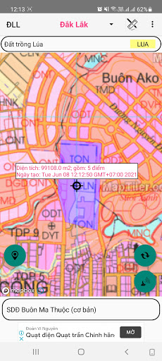
- Free support to look up land use planning in Dak Lak province.- Using Mapbox.coms basemap technology on published land use plans- Determine the users current location on the land use planning map- Use 02 coordinate systems Longitude, Latitude and coordinate system VN2000- Support map zoom function, rotate Map in North-South axis- Find and remember current location by name- Electronic compass (only supports devices with magnetic induction chip)- Support for customizing transfer calculation parameters- Save and display the saved points and areas on the map by Object, Project- Change color, option to hide and show objects and points in the project- Save the free drawn area- View, Edit, Delete, Find Landmarks- Function to navigate to objects, save points- Support the function to redraw survey route over time- Support function to display map styles from mapbox.com- Draw Points, Polygon Domains; Measure Distance, calculate Area- Export point data into .kml .gpx .
file types- Support import point data from .gpx .
file- Send and exchange data of save points- Supports conversion tools between coordinate systems
Secure & Private
Your data is protected with industry-leading security protocols.
24/7 Support
Our dedicated support team is always ready to help you.
Personalization
Customize the app to match your preferences and workflow.
See the Bản đồ QH SDĐ Đắk Lắk in Action


Get the App Today
Available for Android 8.0 and above